
Winona became a port city the moment someone set foot on its shores.
People living on the sandbar needed goods, including native people prior to the European invasion. Once the sandbar became a village, some of its inhabitants began producing things other people needed. A river of commerce naturally arose. It is this reason that most of Minnesota’s major urban centers, including Mankato, Minneapolis, St. Paul, St. Cloud, Duluth, Moorhead, and East Grand Forks, were built upon what are, or once were, navigable waters.
In January 1834, 230 steamboats and 4,000 flatboats were listed on the Mississippi. Cargo included animal skins, lumber, grain, meat and coal. The South sent cotton, sugar, molasses and miscellaneous freight. Winona was weaned on wood. The lumber industry fed and sustained the city’s port, which became a major assembly point for floating logs.
People are also reading…
Grain also was king. Visitors to Winona said there were warehouse and elevators everywhere on the river levee. Winona, along with Hastings and other river cities, precipitated the great grain avalanche, which ended just before the turn of the century. This period gave the Midwest a nickname: breadbasket of the world.
Even in its first years of European settlement, Winona was recognized as the best shipping point for the two tiers of counties in southern Minnesota.
So Winona grew alongside other Mississippi River cities: Minneapolis, St. Paul, Dubuque, Davenport, Rock Island, Burlington, Keokuk, Quincy, St. Louis, Cairo, Memphis, Baton Rouge and New Orleans.
A Republican Herald reporter described Winona’s shipping in 1856:
“The river was open to navigation from April 8th to November 17th; and during that time there were 1,300 arrivals and departures of boats. A tri-weekly line of steamers was maintained for the greater part of the season between Winona and Dubuque, and the forwarding and commission business for that one season aggregated $182,731.96.”
Businessman Philip Morrison arrived in Winona in April 1856. In his first letter to his Rebecca, his wife over in Michigan, he described his new home:
“It is my opinion that this will be a good point for business and it is truly a beautiful place and now numbers about three hundred inhabitants situated on the prairie on the bank of the Mississippi. We have from one to three steamboats every day — it makes things look very lively....”
A week later, Morrison wrote: “We have had stop here today 10 fine steamboats, and they all put off more or less goods and people.”
In the spring of 1857, it was noted by an observer that Winona was the primary gateway to southern Minnesota, “with hundreds of steamboats stopping each month of the navigation season.”
The industrial revolution of the early 1900s made the city a railroad junction. During World War I, however, railroads were overloaded by increased traffic, so the government built fleets of barges and towboats. After the war, a government-controlled Inland Waterways Corporation regulated thenew service idea — river as shipping canal. But large-scale shipping in Winona really began once the federal government began shaping the river into a commerce corridor. In the 1800s and early 1900s, the U.S. Army Corps of Engineers performed some navigation engineering, but nothing like what was to come in the 1930s.
That is when it embarked on nearly a decade of lock and dam construction. When completed in 1938, the river had been converted into series of lakes, or pools, and its depth was maintained at a minimum of 9 feet for the passage of shipping barges. And it meant that Winona’s port facilities would become a major stopping point on the river between Minneapolis and St. Louis. In a 1939, publication touting the feat, the Upper Mississippi Waterway Association said: “When the navigation season opens in the spring of 1940, barges will be able to travel over 4,000 miles on a 9-foot waterway from the Gulf to the Twin Cities, and from the Twin Cities to Chicago and Pittsburgh. “All river communities will be brought nearer to the sources of raw materials for their manufacturers, and all river communities will also serve as ports for trans-shipment of commodities moving to and from inland areas.”
The association went on to say, in 1939:
“It has been aptly predicted by competent economists that history will show the expenditure of government money for the canalization of the upper Mississippi river to be one of the most important factors in bringing about the rebuilding of this landlocked territory.”
Lock and Dam 5A, just northwest of Winona, was completed in 1936 at a cost of $3.44 million. It created a pool nearly 10 miles long. The pool covered 7,000 acres of land, and necessitated the clearing of 6,170 acres of formerly dry land.
In 1940 the city agreed to buy 618 feet of river shoreline for $12,580, making the total city-owned shoreline to more than 1,500 feet. The city knew of its value — it would serve it as it had in the past —a tolling gate to attract commerce and collect fees and taxes. The city opened its own municipal harbor in 1958. In 1967, the city served 27 barges in its harbor, moving 34,174 tons of commodities that included rock salt, industrial clay, phosphate, fertilizer and scrap iron.
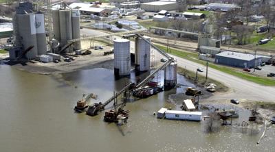
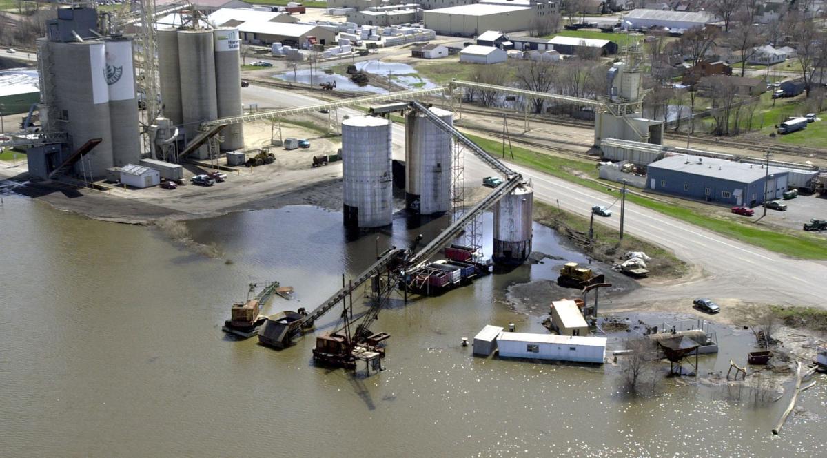
The Port Authority was established by the Winona City Council in 1968. It was chartered to foster economic development in the city. It has the authority to acquire and improve land for commercial development, establish industrial districts, create tax increment finance projects and prepare finance packages to enable business establishment and expansion. In 2000, the city announced plans for a $1.5 million harbor expansion project to make room for more barges loading and unloading bulk commodities in the city. The project would involve a half-million cubic yards of material from Winona’s commercial harbor on the Mississippi River, located along Riverview Drive.
Winona’s harbor was equipped for about 1,300 barges a year when it was built in 1958, but traffic exceeded 2,000 in 1999. The harbor is a terminus for barges, trucks and trains. Trucks entering the city are directed along U.S. Highway 14 to Pelzer Street, which leads to industries on Theurer Boulevard, or to Riverview Drive and the port. Several industries are located in theharbor, including two large grain brokers, Cenex Harvest States Cooperatives and Archers Daniels Midland Gromark.
Trains come to Winona on Railway to the north and south, and on a Dakota, Minnesota and Eastern Railroad route to the west. They can enter the port on track owned by Union Pacific Railroad.
Today, Winona is one of five Minnesota river ports for barges on the Mississippi River.
But new forces are challenging the river navigation system. The environmental movement that sprang up in the late 1960s led to a build-up of sophisticated opposition to river shipping by 2001.
The river’s navigation authority — the U.S. Army Corps of Engineers — and its motives, came under heated fire in the late 1990s and early 2000s for doctoring economic data to justify barge shipping. Winona, as a major river port, was one of the hubs of this debate. A multitude of government and private interests on both sides of the river navigation issue had reached no consensus by late 2001.
A navigation study, which had been halted by the Corps scandal, resumed the summer of 2001, with promises by the Corps it would include an environmental assessment of shipping impacts on the river.
Whatever the outcome of this, the river is very likely to remain a shipping channel for years to come, securing Winona’s place as an industrial community with a welcome mat at the port.
This story was firt published in the Sept. 16, 2001 Winona Daily News.